X
0

0

Days

Crossing the Ramon Crater

(Rate)

ื”ื™ื™ืฉื•ื‘ ื”ืงืจื•ื‘

ืจืžืช ืงื•ืฉื™

ื‘ื™ื ื•ื ื™-ืงืฉื”

ืื•ืจืš

18 ืง"ืž

ืžืฉืš

5-6 ืฉืขื•ืช

ืขื•ื ื” ืžื•ืžืœืฆืช

ื–ืžืŸ ืžื•ืžืœืฅ

Day

01

28 km

Start point

End point

Nahal Gevanim Overnight Campground

5-6 hours

We begin the hike heading south on the green-marked trail, which starts at the Albert Promenade along the edge of Ramon Crater, near the southwestern neighborhoods of Mitzpe Ramon. At the start of the trail, we recognize that we are walking along a relatively well-preserved ancient camel path.
As we descend into Ramon Crater, weโ€™ll see a blue-marked trail branching off to the right, but we continue on the green trail alongside the black hill and down into a small wadi. After descending into the ravine, weโ€™ll notice, on our left, black quartzite prisms (resembling basalt columns).
Here we merge southward onto the marked trail, with the town of Mitzpe Ramon now behind us to the north. It’s possible to take a shaded break under a lone acacia tree, next to the spot where the trail crosses Nahal Ramon. This section of the trail also follows the Israel National Trail.
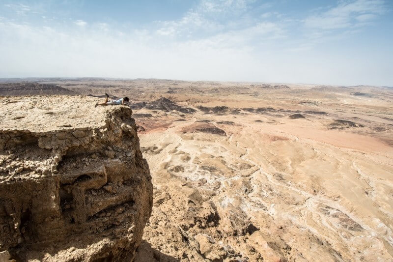
The trail begins a moderate ascent toward the southern cliffs of Ramon Crater. Further along, weโ€™ll see a green-marked trail splitting off to the left, but we stay on the red-marked trail, which leads us directly to the summit of โ€œShen Ramonโ€โ€”a dark granite peak that stands out against the limestone cliffs forming the southern wall of the crater. At this impressive point, itโ€™s worth pausing to take in the sweeping desert views before you.

We descend from the other side of the mountain and continue along the winding trail that curves left (east) toward the famous โ€œAmmonite Wallโ€ in the southern part of the crater, near Route 40. Just east of the Ammonite Wall, weโ€™ll spot a green-marked trail branching north from the red trail.
The green trail becomes part of the Israel National Trail, and we continue on it with a slight northward bend, with Route 40 stretching to our right. We cross Route 40 to the other side (east), and from here on, we continue along a well-defined jeep road marked in green (also part of the Israel Trail). At the junction with Route 40, weโ€™ll see a brown tourist sign that reads โ€œNahal Gevanim.โ€
We follow this dirt road for about 2.5 kilometers, between two ridges dotted with acacia trees. When we spot a high-voltage power line crossing above us, weโ€™ll recognize the Nahal Gevanim Overnight Campgroundโ€”our place to sleep for the night.

Read more
Day

02

km

Start point

Nahal Gevanim Overnight Campground

End point

5-6 hours

We leave the overnight campground heading south on the wide dirt road marked with black trail markers. The trail climbs steeply to the summit of Mount Saharonim. The ascent is indeed challenging, so take a few moments to catch your breath and enjoy the view.
After the climb, we turn left (northeast) onto the green-marked trail. Note that after 100 meters, when reaching a small cliff, youโ€™ll need to use metal handholds for support. We continue ascending along the ridge with views of the crater to our left. This scenic trail passes through tilted layers of marine sedimentary rock, shaped by the massive folding caused by the Ramon Faultโ€”one of the five major cross-faults in the Negev.
Along the Mount Saharonim trail, weโ€™ll notice two peaks (domes). After descending from the second peak, the trail splits, and we take the green trail to the left, which leads us into the Ramon streambed below. The trail brings us directly to Ein Saharonimโ€”a modest desert spring, indicated mainly by the variety of desert vegetation made possible by this vital water source. The spring flows visibly only in some years, typically after strong winter rains.
Here you can take the opportunity to climb slightly north to the ruins of Khan Saharonim and the adjacent small fortress. This ancient Nabatean khan served travelers on the Incense Route more than two thousand years ago.
From this point, we follow the blue trail south toward the famous Nekarot Horseshoe (Parsat Nekarot). This popular trail winds through the hard sedimentary rock of southern Ramon Crater. In the wide channel of Nahal Nekarot, weโ€™ll see massive bouldersโ€”these fell from the steep surrounding cliffs due to earthquakes and tectonic activity, as Nahal Nekarot crosses a significant geological fault (the Ramon Fault).
The blue trail through Nahal Nekarot (also part of the Israel National Trail) continues through a beautiful narrow gorge, where, after flash floods, water often collects in natural pools.
Exiting the narrow gorge, note that the valley widens. After about 200 meters, youโ€™ll spot a cave beneath a cliff on the right (marked on maps as โ€œNekarot Caveโ€). We continue walking in the pebbly streambed, still following both the Israel Trail and the blue trail markers. Along the way, we pass a green trail on the left, and shortly after, a red-marked jeep road crosses our path.
At this point, the blue trail ends, and our route continues northeast along the black-marked trail, which is also part of the Israel Trail. We follow the black trail into Nahal Ardon, now on a wide and easy jeep track.
Along this part of the trail, we observe the northern cliffs of the streambed, where impressive geological features appearโ€”vertical igneous intrusions that cut through the horizontal, colorful sedimentary layers. These are ancient geological dykes formed by molten magma penetrating ancient cracks in the rock. The magma cooled slowly and solidified, standing out sharply against the surrounding sedimentary rock.
We continue along the Ardon streambed for about one more kilometer, then turn right (north) onto a red-marked trail that leads us up a small ravine. Above us, we can see Mount Charut rising prominently above the valley.
After reaching the plateau, the trail turns left (west) and climbs beneath Mount Charut. From here, you can either bypass the mountain by continuing on the blue-marked trail to the west, which loops back to the streambed and the acacia tree, or choose to climb the mountain and return the same way. This is also a good spot to rest in the shade.
After circling Mount Charut along the red and blue trails, we rejoin the main black-marked trail in Nahal Ardon and continue west on the jeep track. We climb a slanted rock surface that looks like an ancient stone wall lying on its side. After passing a small parking area (Saharonim Plateau Trailhead), we continue west on the black-marked dirt road.
After about one kilometer of walking, we reach a junction marked by a rock in the center. From here, we look for the green-marked trail heading west and follow it for another kilometer until we arrive at the Be’erot Overnight Campgroundโ€”this is the endpoint of the trail.

Read more